A Gilded Globe
It was the golden age of cartography. The shadows leagues beyond the horizon were becoming illuminated by the scores of mariners returning from their discovery quests. Maps of the Americas, Australia, and archipelagos across the vast Pacific Ocean were continually updated with new discoveries and adorned with elaborate calligraphy and mythical creatures of the deep.
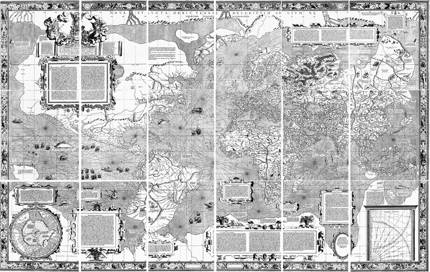
Photo: Mercator 1569 world map from Wikipedia.
The most talented of cartographers were commissioned by the rulers of Europe and wealthy merchants to craft both terrestrial and celestial globes. Gerardus Mercator gained the attention of several future benefactors when he produced his first map of the world in 1538. This was followed by his meticulously crafted globe in 1541. Yet, the flurry of maps, world atlases and globes could barely keep apace of the thousands of updated surveys that were pouring into the ports of Europe. Worse yet, portraying land masses from a sphere on a flat surface did not facilitate accurate navigation over a several hundred-mile voyage.
The rhumb line conundrum was solved when Mercator created a scale on his chart that adjusted for latitude. That is, the higher the latitude the greater adjustment in the geographic scale. This cartographic innovation had a profound impact on dead reckoning sailing; particularly when sailors were unable to update their positions via celestial sightings. Mariners could more confidently ply the seven seas which, in turn, facilitated commerce across what was formerly known as Terra Incognita.
Commerce was alive and well across the Lone Star State as the second quarter of the 21st century dawned. 1% more tows traipsed across the ship channel in 2024 despite the fact that December was the year’s nadir. Blue water movements throughout the ports of Texas were also up 1% in 2024. Unlike the brownwater fleet, December witnessed the greatest number of arrivals for the year.
While Houston did not log the highest annual percentage gain across the state, the port achieved some impressive milestones for the year. One percent more steel rolled across the city docks facilitated by the 2% uptick in general cargo vessels. Bulkers - which generally outpace general cargo calls - further outshined this category with an 8% year-over-year gain. Tankers enjoyed their 2nd best month of the year in December. This particular vessel category experienced one of its best annual percentage gains in years with a 6% rise. While chemical tank arrivals were flat on a year-to-date basis, LPG’s yearly percentage gain matched that of Tankers.
Paradoxically, the container vessel count remains on the wane for the year. Of course, this is rather deceptive given that the port easily pushed through the 4 million TEU mark. Total import and export TEUs were up 6% and 8% respectively. Of particular note, is the fact that empty TEU exports jumped 18% over the past year. The Gulf of America’s – yes, it’s official - largest container port will undoubtedly benefit from the Houston Ship Channel Project 11 channel improvements which will permit even larger container ships to navigate Jesse Jones’s ditch.
Fifty miles away, the Port of Galveston took top honors with respect to annual year-over-year percentage gains. December’s 11% monthly gain was shy of the port welcoming its largest number of deep draft vessels in 2024. Nonetheless, December’s totals for both cruise ships and tankers was not equaled by any other month. More impressive is that fact that tanker arrivals were an eye watering 54% higher than 2023. Chemical tankers were also up 33% for the year.
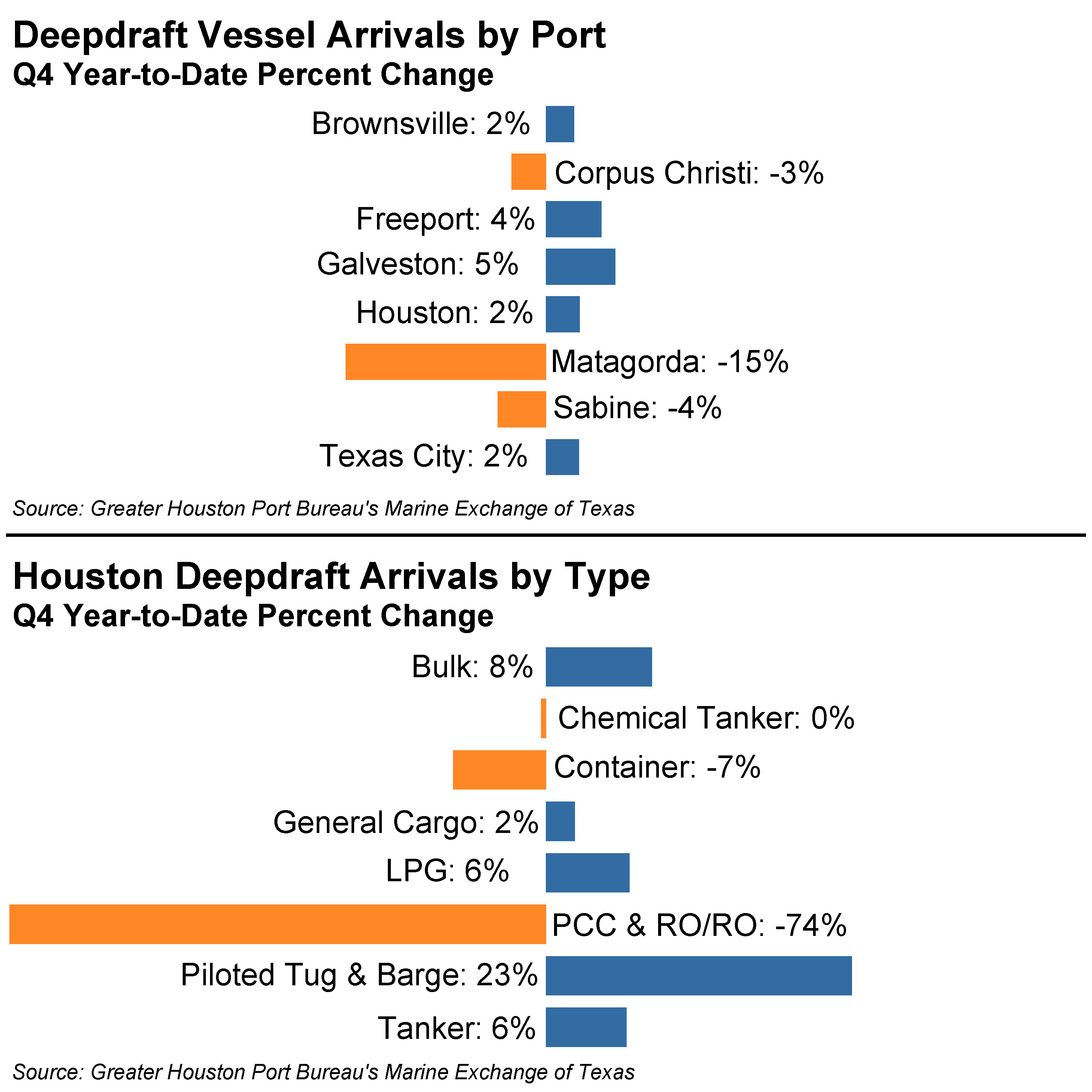 The nearby port of Texas City posted its best December performance in over a half decade. The nation’s most productive rail port, benefited from a bounty of tankers and chemical tankers in the final month of the year. Both categories wrapped up the year on a high note; albeit, tankers were still off 7% for the year. Chemical tankers were up a modest 4% in 2024. This was the primary reason the port tallied a 2% higher vessel arrival count for the year.
Texas’ unsung Port of Freeport continued to quietly climb the vessel arrival charts as it ended the year with the 4th highest total vessel count in Texas. Three vessel categories registered counts that peaked in December – container ships, LPG carriers, and car carriers (RO/RO). The port’s ever-expanding footprint accommodated 3% more container ships and an unprecedented 82% climb in car carriers in 2024. Thus, despite 1% fewer LPG vessels and 17% fewer chemical tankers – the two categories that comprise the lion’s share of vessels that call upon Freeport – the port’s arrival count clicked up by 4%.
Corpus Christi was one of the few Texas ports that did not see a vessel arrival increase in 2024 as reflected in a 3% decline. Tankers, which account for 50% of the arrival totals, fell 5%. The 2nd most frequent caller of the port – chemical tankers – plunged by 12% in 2024. Despite those lows, there were a few bright spots. Bulkers had a robust year with a 21% climb and 74% more general cargo vessels entered its harbor.
The state’s border Port of Brownsville – once again – eked out a modest year-over-year gain of 2%. This bulk-carrier centric port in the state’s hinterland was poised to do a bit better. Unfortunately, December’s 15% fall could not be overcome by the modest increase in tanker calls throughout the year. In light of the tariff chatter that has dominated the air waves as of late, things may be in state of flux for Brownsville.
Finally, on the opposite end of the Gulf Intracoastal Waterway, Sabine’s percentage performance for the year was not too far afield of Corpus Christi. That is, a 4% wane when compared to 2023. Chemical tankers was the sole category that was envied by others as it logged its highest monthly tally for the year and ended 2024 5% ahead of 2023. Tankers, on the other hand, were an unenviable 16% below 2023’s arrival total. The remaining BTU plays – LNG and LPG - also failed to eclipse 2023’s arrival count. Interestingly, bulkers plummeted 20% year-over-yet. Yet, general cargo arrivals leapt 50%. Overall, things were somewhat languid in the state’s second busiest port. No matter, the port’s energy export potential and proximity to a growing population bodes well.
The explosion of maritime activity during the 16th century’s age of discovery certainly boded well for Europe as it focused on trade routes to the west. Mercator’s peers quickly adopted his latitude-based scale as seafarers circumnavigated the globe with greater frequency. By the 1570s, another renown map maker and close friend of Mercator – Abraham Ortelius – began to puzzle over the shape and location of the various continents. He observed that the Americas were “torn away from Europe and Asia”. Ultimately, he concluded, “if someone brings forward a map of the world and considers carefully the coasts of the three continents” it appears that at one point in time they were all one.
This rather creative musing did not garner much attention upon Ortelius’s passing in 1598. Eventually, in 1912 Alfred Wegener published his theory on continental drift documenting that the continents were once one massive land mass that was torn asunder by plate tectonics. Without a doubt, Mercator could never have imagined that his inquisitive fellow cartographer had seen what others failed to grasp for hundreds of years.
About the Author

Tom Marian is the General Counsel of Buffalo Marine Service, Inc. He also serves on the Executive Committee of the Port Bureau Board of Directors.